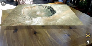
 Geology is a very spatial science and can require a lot of 3-D visualization. Simple physical models (not to mention rocks) have long been used to aid teaching about things like faults or crystalline mineral structure. But these things can be surprisingly costly and occupy a surprising amount of storage space.
Ars talked to Martin Pratt about his work as part of a Washington University in St. Louis group that is developing apps for classes, both for specialized devices like Microsoft’s HoloLens and for the phones most students already have.
While completing a Ph.D. in seismology a few years ago, Pratt had taken an interest in data visualization along the way. He took on the challenge to work on creating AR apps, starting with one (iOS only) that allows users to explore up-to-date USGS earthquake data in three dimensions rather than just a 2-D map. You can much more easily understand the geometry of a tectonic plate boundary this way, or even explore the pattern of foreshocks and aftershocks around an earthquake.
See the full story here: https://arstechnica.com/science/2020/09/augmented-reality-could-be-the-geology-classrooms-killer-app/